


VOR ILS GPS
VOR ILS GPS介绍
This application is NOT CERTIFIED to be used FOR FLIGHT GUIDANCE.
Use only in Visual Meteorological Conditions.
Do not use as single source of guidance.
The developer is not responsible for damage resulting from incorrect usage of this application.
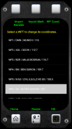
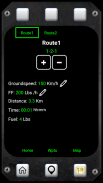
- You must define a reference point: VOR, ADF, NDB, or the touchdown point of a runway.
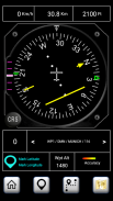
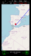
- The Horizontal Situation Indicator will provide indications to this point.
- The green arrow indicates the heading to the reference point.
- If the reference point is the touchdown point in a runway, the HSI will provide also indications to fly a 3º glideslope to that point (simulating an ILS approach).
- Choose the course you want to follow. The Course Deviation Indicator will diplay a deviation up to 10º each side of the selected course.
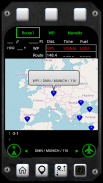
- The reference point must be defined introducing its coordinates and gps altitude. You can introduce up to 20 waypoints.
- You can save the coordinates of your current position by pressing the Mark button and importing them as a new waypoint.
Example:
N 40º 22' 12.92"
W 003º 46' 36.4"
Connect the location sensor of your device.
The information provided during the first two minutes (mainly the altitude data) will not be reliable.
Warning: Some devices do not provide gps data when in battery low mode.
此应用程序没有通过验证飞行指导使用。
只能使用在目视气象条件。
不要为指导的单一源使用。
开发商是不负责从该应用程序的不正确使用造成的损坏。
- 必须定义一个基准点:VOR,ADF,NDB,或跑道着陆点。
- 在水平位置指示器将提供指示这一点。
- 绿色箭头指示的标题参考点。
- 如果参考点是着陆点在一个跑道,HSI还将提供指示至一3º下滑道飞行到该点(模拟的ILS的方法)。
- 选择要遵循的过程。航道偏离指示器将diplay偏差高达10度的选定的过程的每一侧上。
- 参考点必须被定义引入其坐标和GPS高度。您可以引入多达20个航点。
- 您可以通过按标记按钮并输入他们作为一个新的航点保存您的当前位置的坐标。
例:
Ñ40°22' 12.92"
W¯¯003º46' 36.4"
连接您的设备的位置传感器。
前两分钟期间提供的信息(主要是海拔数据)将不可靠。
警告:某些设备不电池低模式下,提供GPS数据。
VOR ILS GPS - APK信息
APK版本: 4.0程序包: appinventor.ai_bolo122.GPSVORILSVOR ILS GPS的最新版本
其他版本


同类应用


